
Nairobi to Amboseli Road Conditions: Driver’s Guide
Last Fact-Checked & Road Verified: August 2026
Road Conditions at a Glance
| Metric | Status & Details |
| Total Distance & Time | 265 km (~4.5 to 5 hours driving time) |
| Asphalt vs. Dirt Ratio | 248 km paved tarmac (A109 & C102) / 17 km unpaved murram gravel |
| Current Road Surface | Good tarmac to Kimana Town; corrugated washboard gravel to Kimana Gate |
| Seasonal Hazards | Unpainted speed bumps on C102; black cotton mud near gates in wet season |
| Vehicle Requirement | High-clearance 4×4 recommended (Mandatory during April–May / Nov–Dec rains) |
Fast Navigation Links
- Leaving Nairobi & Expressway
- C102 Highway Hazards & Signal Loss
- Kimana Gravel, Tire Pressures & Mud
- Route Comparison & Gate Options
- Prefer Not to Drive? 4×4 Guided Tour Alternatives
- Frequently Asked Questions
Driving from Nairobi to Amboseli National Park covers roughly 265 kilometers. Once you clear the industrial zones of Syokimau and pass the heavy cement factories near Athi River, the landscape opens into the dry Kapiti Plains.
We run this route every week to drop guests at the gates. Standard GPS estimates usually project a clean four-hour trip, but your actual driving time depends on police speed traps, freight truck traffic near Emali, and cattle crossings along the C102 tarmac.
Before leaving Nairobi, ensure your KWS entry fees are fully paid through the eCitizen portal. Rangers at the gates will not let you pass without a printed eCitizen PDF receipt. Check our parent Amboseli National Park guide for gate maps and park regulations.
Leaving Nairobi Traffic & The A109 Highway
Heading out of Nairobi via Mombasa Road means navigating heavy commuter traffic around the Inland Container Depot.
Taking the elevated Nairobi Expressway from Westlands or the CBD straight to the final exit at Mlolongo skips about 45 minutes of bumper-to-bumper industrial traffic. The toll cost for a Class 3 vehicle to exit at Mlolongo ranges between KES 360 and KES 500 (~$2.50 to $3.85 USD) depending on your entry ramp. Toll booths accept cash, M-Pesa, or pre-loaded MTC/ETC cards.
After joining the A109 highway at Mlolongo, monitor your speed closely. Police set up mobile speed radar traps on the long downhill run approaching the Kyumvi/Machakos turnoff and near the Lukenya hills. The limit drops sharply from 100 km/h to 50 km/h as you approach these roadside trading posts.
M-Pesa payment is mandatory for traffic fines at police checkpoints—cash won’t work.
At Emali, you will turn right off the main Mombasa highway onto the C102 Oloitokitok Road. Emali is a primary overnight staging hub for long-haul diesel trucks, so the flyover intersection gets congested between 7:00 AM and 9:00 AM. Watch out for deep ruts on the unpaved shoulders, parked semitrailers, and motorbikes (boda bodas) cutting across lanes.
Essential Road Segment Breakdown
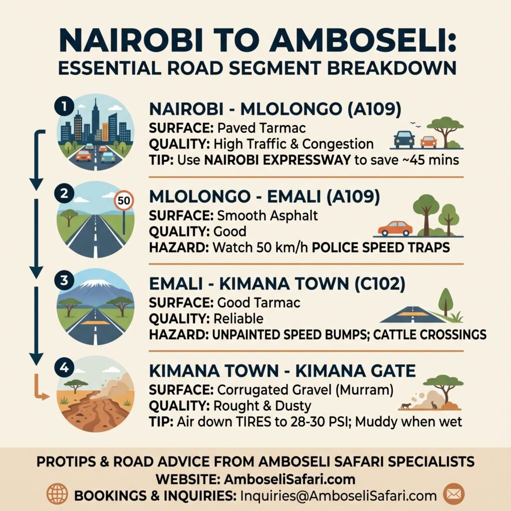
Preparing for the drive from Nairobi to Amboseli requires knowing exact surface conditions and speed trap locations along the way. Below is a quick snapshot comparing every leg of the journey, recommended tire settings, and key highway hazards. Use this quick-reference guide to plan your fuel stops, toll expenses, and total drive times before hitting the road.
| Route Segment | Surface & Quality | Key Hazard / Tip |
| Nairobi – Mlolongo | Paved / High Traffic | Use Expressway to save 45 mins. |
| Mlolongo – Emali (A109) | Smooth Asphalt | Watch 50km/h police speed traps. |
| Emali – Kimana (C102) | Good Tarmac | Unpainted speed bumps; cattle crossings. |
| Kimana – Gate | 17km Corrugated Dirt | Air down tires to 28–30 PSI; muddy when wet. |
C102 Highway Hazards & Signal Loss
Once south of the Emali flyover, you enter the 98-kilometer C102 asphalt stretch toward Kimana Town, with Mount Kilimanjaro visible ahead on clear days.
The C102 tarmac is in good condition, but local authorities have placed narrow, unpainted asphalt speed bumps near trading spots like Sultan Hamud and the Mashuru junctions.
During a drive near Sultan Hamud, morning sun glare blinded senior guide Anthony Mule just long enough to hit an unpainted bump hard, cracking a shock bracket on his Land Cruiser. He had to limp into Kimana Town for an emergency weld, losing two hours of prime viewing around the Enkongo Narok swamp.
Between 10:00 AM and 11:30 AM, and again around 4:30 PM, Maasai herdsmen move large herds of cattle and goats across the C102 to reach roadside water troughs.
Never honk at cattle on the road; it causes the herd to scatter unpredictably across both lanes. Stop completely and wait for the herdsmen (Morans) to wave you through with their wooden sticks (rungu).
Cell phone coverage drops significantly past Sultan Hamud along the C102.
Download offline maps on Google Maps or Maps.me while you still have Wi-Fi in Nairobi so you don’t lose navigation in signal dead zones.
Kimana Gravel, Tire Pressures & Mud
The paved road ends past Kimana Town, giving way to a 17-kilometer corrugated gravel track leading directly to Kimana Gate.
Driving over these washboard ridges at 20 to 30 km/h will shake the vehicle violently, loosening bolts and rattling dashboard trim. Increasing your speed to 50 or 60 km/h allows the tires to float across the top of the ridges for a smoother ride, but it requires firm control on loose gravel.
Deflate your tires to 28–30 PSI before starting on this gravel section to absorb vibrations and improve grip.
Sharp volcanic stones along this track frequently cut sidewalls, so carry two fully inflated spare tires and a functional bottle jack. Read our Amboseli self-drive tips for recommended vehicle setups.
During the long rains (April–May) and short rains (November–December), the volcanic soil along this 17-kilometer stretch turns into sticky black cotton mud. Treads clog instantly, making high-clearance 4x4s with all-terrain tires essential to avoid sliding into side ditches.
Fill up at the TotalEnergies or Shell stations in Kimana Town—there are no fuel pumps inside Amboseli.
Running out of fuel on remote park tracks incurs a mandatory KWS recovery and towing fee of KES 15,000 to KES 25,000 ($115 to $190 USD) to haul your car back to the gate.
Tactical Driving Checklist & Vehicle Specs
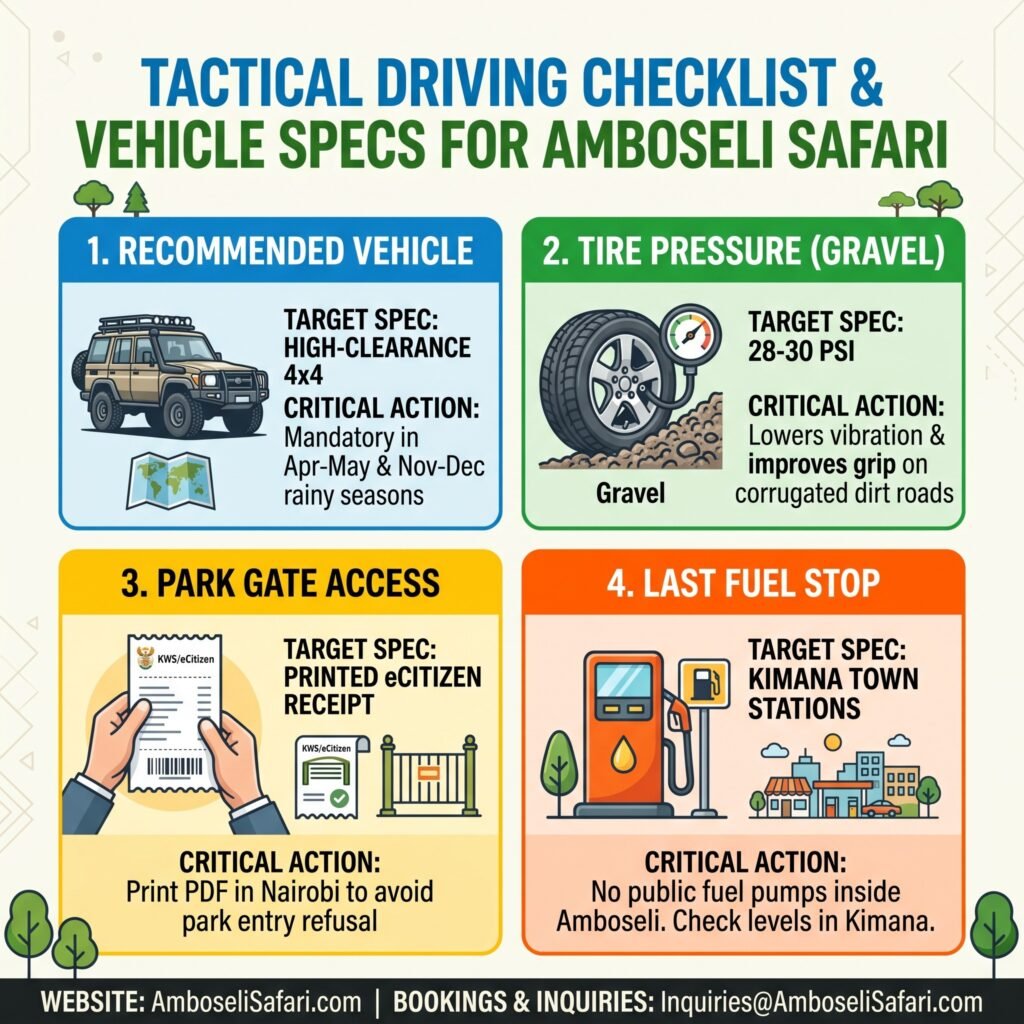
Transitioning from smooth asphalt to 17 kilometers of corrugated murram gravel demands proper vehicle preparation. Reducing tire pressure improves traction on loose stones and helps prevent sidewall punctures on volcanic rock. The table below highlights critical technical specifications every driver should check before exiting the tarmac at Kimana Town.
| Metric / Requirement | Target Spec | Critical Action |
| Recommended Vehicle | High-clearance 4×4 | Mandatory in Apr–May / Nov–Dec rains. |
| Tire Pressure (Gravel) | 28–30 PSI | Lowers vibration; carry 2 full spare tires. |
| Park Gate Access | Digital eCitizen Receipt | Print PDF prior to leaving Nairobi. |
| Last Fuel Stop | Kimana Town | No public fuel pumps inside Amboseli. |
Route Comparison & Gate Options
Choosing the best route and entry gate depends on where you are starting from and which side of the park your lodge sits on.
Route Comparison: Emali vs. Namanga
| Feature / Metric | Emali Route (C102 via A109) | Namanga Route (A104) |
| Distance from Nairobi | ~265 km | ~240 km |
| Road Conditions | 248 km tarmac, 17 km corrugated gravel | Paved to Namanga, 50 km unpaved dirt |
| Primary Hazards | Speed traps at Kyumvi, Emali truck traffic | Fine fesh-fesh dust trenches, donga ruts |
| Best Entry Gates | Kimana Gate or Iremito Gate | Meshanani Gate |
| Overall Recommendation | Recommended (Faster, smoother tarmac) | Rougher (Requires full 4×4 engagement) |
1. Iremito Gate (Best for Northern Camps & Direct Nairobi Access)
Turn right off the C102 tarmac roughly 64 km past Emali onto a 20-kilometer unpaved track before reaching Kimana Town. This is the shortest route from Nairobi, putting you near KWS Headquarters and northern camps.
2. Kimana Gate (Main Eastern Gate)
Follow the C102 past Kimana Town and take the 17-kilometer gravel road. This is the primary gate for eastern lodges and visitors traveling from Tsavo West. Read our full profile on Kimana Gate.
3. Meshanani Gate (Western Namanga Route)
If traveling from Arusha or western Nairobi, take the A104 south to Namanga, then head east on a 50-kilometer dirt track. Seasonal riverbeds (dongas) along this track accumulate powdery fesh-fesh dust during dry months, which hides deep ruts. High-clearance 4×4 is required. See our Meshanani Gate access guide.
For complete budget details, review our Amboseli safari cost breakdown or check all entry access points in our guide to Amboseli National Park gates.
Gate Access & Driving Route Comparison
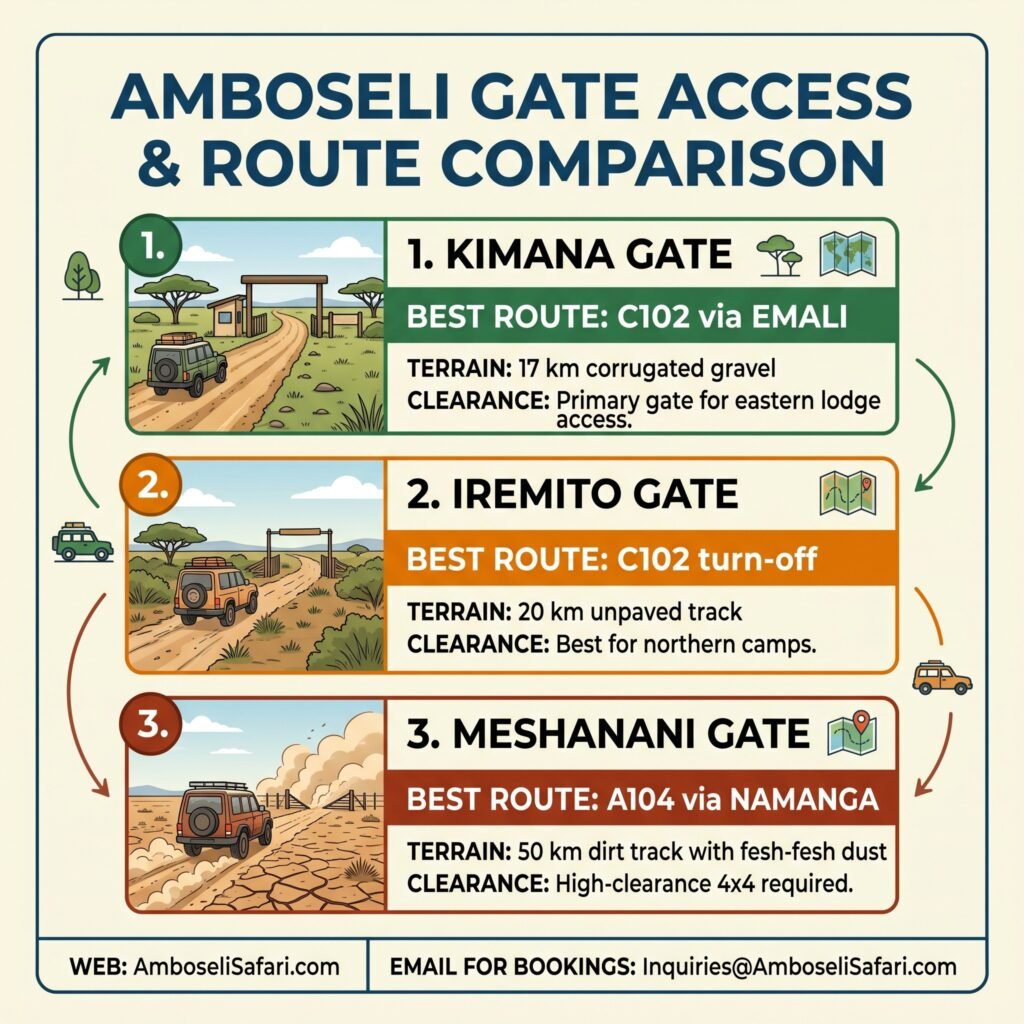
Selecting the right entrance gate depends on your starting location and where your lodge is located inside the park. While the Emali route offers tarmac for the majority of the trip, alternative access points like Meshanani Gate require driving across extended dirt tracks. Review this quick breakdown to select the most efficient route for your vehicle type.
| Gate Option | Best Route | Terrain & Clearance |
| Kimana Gate | C102 via Emali | 17km corrugated gravel; eastern lodge access. |
| Iremito Gate | C102 turn-off | 20km unpaved track; best for northern camps. |
| Meshanani Gate | A104 via Namanga | 50km dirt track; fine fesh-fesh dust & ruts. |
Prefer Not to Drive? 4×4 Guided Tour Alternatives
If navigating washboard gravel, police checkpoints, and mud tracks feels like more hassle than you want on vacation, booking a driven 4×4 is a simple alternative. On Amboselisafari.com, our TRA-licensed guides handle the driving, fuel, speed traps, and eCitizen gate clearances while you focus on the wildlife.
Our package pricing is based on two adults sharing a private 4×4 Safari Land Cruiser. Vehicle rates include fuel, insurance, driver fees, and unlimited game drives at USD 190 per person sharing per day during normal season and USD 400 per person sharing per day during peak dry season (July to October).
We recommend pairing Amboseli with Tsavo West on a 4-day route to see two distinct landscapes without long driving hours.
4-Day Amboseli & Tsavo West Safari Packages
Prices are per person, based on two adults sharing a 4×4 Land Cruiser and double room.
| Season & Tier | Included Lodges | Price Per Person (USD) | Reserve Your Spot |
| Normal – Budget | AA Lodge Amboseli & Rhino Valley Lodge | USD 1,370 | Book Now |
| Normal – Mid-Range | Ol Tukai Lodge & Kilaguni Serena Lodge | USD 1,610 | Book Now |
| Normal – Luxury | Tortilis Camp & Severin Safari Camp | USD 2,150 | Book Now |
| Normal – Luxury Plus | Angama Amboseli & Finch Hattons | USD 3,560 | Book Now |
| Peak – Budget | AA Lodge Amboseli & Rhino Valley Lodge | USD 2,300 | Book Now |
| Peak – Mid-Range | Ol Tukai Lodge & Kilaguni Serena Lodge | USD 2,600 | Book Now |
| Peak – Luxury | Tortilis Camp & Severin Safari Camp | USD 3,250 | Book Now |
| Peak – Luxury Plus | Angama Amboseli & Finch Hattons | USD 5,050 | Book Now |
Included in the Package:
- Private customized 4×4 Safari Land Cruiser with pop-up roof.
- Services of a licensed, English-speaking driver-guide.
- All KWS park entry fees for Amboseli National Park and Tsavo West.
- Full board accommodation (breakfast, lunch, dinner) at specified lodges.
- Bottled drinking water in the vehicle throughout the drive.
- Emergency medical evacuation cover.
Package Exclusions:
- International flights and Kenyan electronic Travel Authorization (eTA) fees.
- Driver tips, alcoholic beverages, and laundry.
- Optional activities like hot air balloon flights.
Optional Add-Ons:
- Maasai Cultural Village Visit: USD 30 per person.
- Amboseli Hot Air Balloon Flight: USD 450 per person.
- One-way Fly-in Upgrade (Wilson Airport to Amboseli Airstrip): USD 540 per person (Includes base ticket from the airline, rate protection cushion, and local service fee).
Ready to leave the driving to us? You can let our team design a custom Amboseli safari package directly for your travel dates.
Frequently Asked Questions
How long does it take to drive from Nairobi to Amboseli?
The drive takes between 4 and 5 hours under normal conditions. It covers 150 km on the paved A109 highway to Emali, 98 km on the paved C102 road to Kimana Town, and a final 17 km on unpaved gravel to Kimana Gate. Using the Nairobi Expressway to Mlolongo saves about 45 minutes of city traffic.
Can I drive to Amboseli in a small 2WD car?
During the dry season, a 2WD sedan can reach Kimana Gate via the paved C102. However, driving inside the park or taking the final 17 km dirt stretch in a low-clearance car is risky. Loose gravel, black cotton mud after unexpected rains, and deep ruts can easily damage low bumpers. We strongly recommend a high-clearance 4×4.
Where is the last place to buy fuel before entering the park?
Kimana Town is your absolute last stop for commercial fuel. Fill your tank at the TotalEnergies or Shell stations in Kimana or Emali before approaching the park gates, as there are no public fuel pumps inside the reserve boundaries.